
Ten years of Marine Protected Areas in California
- Rikki Eriksen, Ph.D.

- Jun 27, 2022
- 4 min read
A reflection of what has been accomplished across our network of MPAs

Just ten years ago California became home to the first network of marine protected areas (MPAs) in the United States. When they were put in place, many were skeptical, others hopeful, some celebrated, but few knew what to expect. About 852 square miles of ocean– a little over 16 percent of the state’s waters – were protected, with about 9% fully protected in strict no-take areas. Rockfish, sea otters, sea stars, sea birds and many other amazing ocean critters now had places of refuge, in 124 MPAs dotting the coast from the borders of Oregon to Baja. But how to get the word out?
That’s where the California Marine Sanctuary Foundation (CMSF) stepped in, playing a critical early role leading the charge in educating Californian’s and coastal visitors about the new network. Anglers wanted to know where they could fish, charter captains needed to know where to take their guests, divers were keen to watch places recover, and others wanted to find new areas to explore. Recently, we just released a report that highlights our accomplishments over the past 10 years to increase awareness about the network of MPAs.

At the start, there was little existing in the form of outreach materials. We launched the user-friendly www.CaliforniaMPAs.org website, and over time it has grown to become a resource repository filled with hundreds of educational tools. A big obstacle was that no one really knew where these places were; signs were needed up and down the coast. Working with state agencies (California Department of Fish and Wildlife and Ocean Protection Council), CMSF created and installed almost 500 signs- all with a recognizable look and feel. We crawled down steep cliffs, walked hundreds of miles of coastal trails, met with Tribal elders, and talked with boaters and locals, searching for the best places. From public marinas, remote boat launches, aquaria, visitor centers, natural history museums, waterfront areas to obscure trailheads, signage today helps orient visitors to their local MPAs. Some share facts about migrating whales, nesting birds, efforts to restore kelp forests or ways to get involved as community scientists.
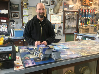
But what if you happened to be driving the coast or buying tackle before heading out on the water fishing?A resource that could be handed out to coastal visitors was crucial. So, we created brochures with maps, photos, and specific information for MPAs near every major California harbor. Many were waterproof so boaters could bring the fold out maps onto their vessels and get the nitty gritty details. What gear was allowed? Could tackle touch the bottom? Was kelp harvest allowed? Over 130,000 brochures were placed in the hands of ocean enthusiasts. Anglers learned where to find on-the-water information from the 20,000 postcards we placed in bait and tackle, sporting goods stores, and marina offices, and over 50,000 Tidebooks included MPA maps and details for surfers, boaters, intertidal explorers, and anglers. The word was out, and new ways of reaching important voices and audiences were tested.


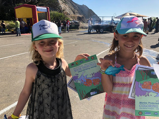
What many may not realize is that many MPAs border California State Parks. So, it made sense that we partner early on to create a suite of resources that could reach kids, families, and other ocean enthusiasts. Colorful posters, exhibits, trainings, presentations, and factsheets were created and given to local NGOs. Over the years these early tools have been improved – they have been translated into Spanish, focused on local Tribal traditions, and a host of geocaches, coloring books, videos and mobile carts target kids and families. Each year we train docents and local clubs on what is happening in nearby MPAs and highlight trends in ocean health.
With the increasing popularity of social media, CMSF developed MPA specific social media accounts to highlight the MPA network. On Instagram, Facebook, and YouTube, close to 5 million people learned where these special places are and what they are all about. People shared accounts from fishing trips, field trips, weird sightings, and images of families tidepooling, surfing and having fun exploring the coast. Many found these places by reading the factsheets and webpages that we created for every single MPA.


Thanks to great collaborations with
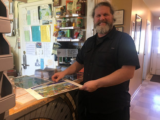
boaters, charter fishing, kayak and SCUBA businesses and anglers, we placed advertisements in popular fishing magazines and on websites like Western Outdoor News & Fish Sniffer, and regularly attended boat shows, Sportsmen Expositions, and fishing club meetings. Exhibits for trade shows were used at harbormaster meetings, Clean Marine events, and by local NGOs up and down the coast. Almost 500 waterproof guides filled with pages of local photos and fun facts were given to charter boats and wildlife tour companies. These family-friendly guides are great for on-the-water use, especially when the fish aren’t biting and the whales aren’t making an appearance.
Trying to wrap my head around a decade of hard work, I realize how far we’ve come. When we started, you would be hard pressed to find much information on MPAs in California, and today hundreds of resources exist for different audiences and for every single MPA. That doesn’t mean our work is done, but every now and then its nice to take stock in how far we’ve come. We got here thanks to you, your suggestions, your knowledge, your enthusiasm, and concern. It’s a moment of pride, for us as an organization, and for us collectively. It fills me with energy, knowing that we have farther to go and more to learn from you. Who do we still need to reach, what messages aren’t getting through and what do you want to learn about now- 10 years on? I look forward to hearing from you all, and for the work ahead.


