
Marine Conservation
Responsible Shipping
Ship traffic poses significant collision risk to whales. Off the West Coast alone – a major entry point for international goods to the U.S – an estimated 80 whales a year are struck and killed by ships. CMSF coordinates ongoing regional efforts to promote sustainable shipping practices that reduce the risk of fatal ship-strikes on endangered whales through the Protecting Blue Whales and Blue Skies (BWBS) Program.
Partnering with NOAA’s National Marine Sanctuaries, several California county air pollution control and air resource management districts, research and other NGO partners, BWBS incentivizes ship operators to cooperate with California's voluntary Vessel Speed Reduction (VSR) requests to protect whales, coastal air quality, and decrease underwater noise and regional greenhouse gas emissions.
-
Participating Shipping Companies: include some of the world's largest players in maritime trade. The program is open to container, bulk, tanker, car carriers, and new for the 2026 Season, cruise lines.
-
Ambassadors: work to increase the demand signal for more responsible shipping practices and raise awareness about biodiversity and air quality protection opportunities in supply chains. The program is open to consumer goods, brands, retailers, ports, freight forwarders and logistics companies that import or export via California ports.
-
Verification: BWBS synthesizes vessel AIS data for each fleet to verify cooperation rates and works with third-party researchers and consultants to calculate the program's environmental impact.



M2
CMSF partners with Resources Legacy Fund and ProtectedSeas to pilot shore-based radar monitoring systems, known as Marine Monitor (M2). These systems track vessel activity within nearshore areas, providing an enhanced understanding of human uses and activities in the marine areas where monitoring systems are deployed.
Whale Population Surveys
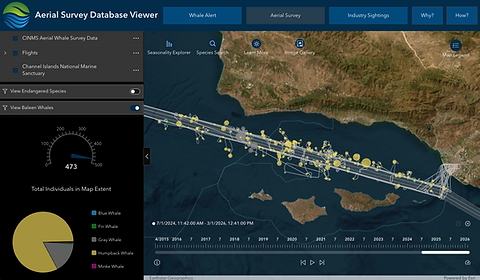
To better inform Vessel Speed Reduction (VSR) efforts, CMSF is a project partner in support of the Channel Islands National Marine Sanctuary's aerial survey program that seeks to better understand the distribution and density of large whales in the Santa Barbara Channel region.
CMSF's ArcGIS Online Experience Aerial Whale Survey Map allows users to visualize and explore some of the datasets collected or maintained by CMSF. This map includes the Industry Sightings Viewer, Whale Alert Viewer and Aerial Survey Program Viewer.
More on the aerial program and why this data is critical for informing management efforts: Aerial Whale Survey Program Story Map


eFINS
In collaboration with NOAA’s Channel Islands National Marine Sanctuary, CMSF supports projects focused on piloting innovative technologies to improve, track, and understand threats to California’s coastal and marine resources. Since 2015, we’ve partnered with CINMS, Resources Legacy Fund, the California Department of Fish and Wildlife, and the Channel Islands National Park to build, launch, and maintain a mobile data collection app called the electronic Fisheries Information Network System (eFINS). The app is being piloted statewide as a mechanism for marine wardens and officers to easily collect and share important information from enforcement encounters while patrolling offshore areas.
eFINS
In collaboration with NOAA’s Channel Islands National Marine Sanctuary, CMSF supports projects focused on piloting innovative technologies to improve, track, and understand threats to California’s coastal and marine resources. Since 2015, we’ve partnered with CINMS, Resources Legacy Fund, the California Department of Fish and Wildlife, and the Channel Islands National Park to build, launch, and maintain a mobile data collection app called the electronic Fisheries Information Network System (eFINS). The app is being piloted statewide as a mechanism for marine wardens and officers to easily collect and share important information from enforcement encounters while patrolling offshore areas.
PaC-Whale: The Eastern Pacific Collaborative to Reduce Vessel Impacts on Whales
CMSF serves as Secretariat for an international collaborative along the eastern Pacific that stretches from Arctic Waters down to the southern tip of Chile.
PaC-Whale ensures collaboration and connectivity across various management entities, research groups and NGOs to develop and align comprehensive, data-driven protection measures that mitigate the impacts of maritime traffic—specifically vessel collisions, underwater noise, and emissions—on whale populations.
Alongside WWF Mexico and the Universidad de Colima, Manzanillo, CMSF convened an international group of conservation managers and practitioners in May 2026. This workshop fostered cross-sector collaboration to identify critical gaps in data, policy, and geographic protections; facilitate the exchange of lessons learned and successful mitigation strategies currently implemented across the Pacific region; and evaluate the scope and feasibility of implementing voluntary vessel speed reduction and protection measures in the Mexican Pacific.

eFINS
In collaboration with NOAA’s Channel Islands National Marine Sanctuary, CMSF supports projects focused on piloting innovative technologies to improve, track, and understand threats to California’s coastal and marine resources. Since 2015, we’ve partnered with CINMS, Resources Legacy Fund, the California Department of Fish and Wildlife, and the Channel Islands National Park to build, launch, and maintain a mobile data collection app called the electronic Fisheries Information Network System (eFINS). The app is being piloted statewide as a mechanism for marine wardens and officers to easily collect and share important information from enforcement encounters while patrolling offshore areas.

Offshore Renewable Energy
The overarching challenge with the development of new industries or technologies is trying to anticipate their effects on the environment.
In coordination with the Ocean Protection Council and in collaboration with over 200 scientists, CMSF is leading the development of a neutral, transparent, and science-based environmental monitoring guidance for California's emerging offshore wind industry.